Sunday, September 18, 2022

Volcanic Activity in Chile

According to the Smithsonian website, Chile has 91 Holocene volcanoes.  Ten of those have erupted within the last 20 years.  Most large volcanoes in Chile are stratovolcanoes also called composite volcanoes. They are tall and cone-shaped made up of many layers of hardened lava and volcanic ash. Cinder cones are smaller than stratovolcanoes and are steep and cone-like in shape. In Chile there is also plenty of hydrothermal activity and is found where there is volcanic activity under the Earth’s crust. Geyser is a type of hot spring that erupts regularly, throwing hot water and steam into the air. There are also hot springs and fumaroles in Chile.  


The Southern Andean Volcano Observatory (SpanishObservatorio Volcanológico de los Andes del Sur), also known by its acronyms as OVDAS, is part of Red Nacional de Vigilancia Volcánica, a program of the Chilean National Geology and Mining Service to watch the 43 most dangerous volcanoes of Chile. In 2012, there were 30 volcanoes under observation.


Based off the USGS website, the eruption of the Chaitén Volcano in Chile, on May 26, 2008 influenced the Chilean government to plan a National Volcano Early Warning System (NVEWS) modeled after a 2005 USGS report proposing a monitoring strategy for U.S. volcanoes. The strategy ranks hazards posed by volcanoes into threat levels, assesses the monitoring gaps, and recommends upgrading the monitoring capability according to the threat level.  This monitoring network assists them to transmit data in real time to help warn the public of further eruptions.  This system will ensure proper evacuation time and could save countless lives.    


Sources:

Volcano Watch — Surprise Eruption in Chile Sparks Interest in National Volcano Early Warning System | U.S. Geological Survey (usgs.gov)

Global Volcanism Program | Chile Volcanoes (si.edu)

List of volcanoes in Chile - Wikipedia

Volcanoes of Chile | Chile Culture

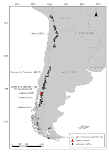
Map-of-active-volcanoes-in-mainland-Chile_Q320.jpg (320×320) (researchgate.net)


Wednesday, September 7, 2022

Earthquakes in Chile

     Chile is a hotspot for earthquakes because the Nazca plate, a tectonic plate which moves eastwards with a rate of 6.6 cm per year, collides with the South American plate off the Chilean coast.  The Nazca plate is submerged below the South American plate, and the pressure building up between the two plates is eventually released in the form of an earthquake.  The strongest earthquake ever recorded by modern instruments was a 9.5-magnitude quake on May 22, 1960, which was centered offshore in southern Chile, where it set off a huge tsunami.

    After being hit by the planet’s largest-ever recorded earthquake back in 1960, Chile developed strict anti-seismic building codes. Despite this, an 8.8-magnitude earthquake in 2010 wreaked destruction in southern and central parts of the country. More than 500 people were killed by the quake and the tsunami that followed. More than 200,000 homes were flattened. Things had to change again. Building codes were updated so structures could better withstand seismic waves. Strong columns and weak beams meant buildings would have a better chance of swaying with the tremors and avoiding collapse. Pressure was also exerted on planners for any new buildings to be constructed further from the sea.

    Also, having learned from the past, better early warning systems are now in place. The National Seismological Centre in Chile functions around the clock since the government invested in a network of sensors throughout the country to record seismic activity. If there is going to be a big one, they’ll be alerted.  Chile survived a big quake with relatively few casualties because it was ready for it. For many years now, local groups around the country have been familiarizing themselves with disaster preparedness plans, practicing countless earthquake drills and running through evacuation routes time and time again. The result? More than one million people were evacuated from coastal areas in a matter of hours, escaping the tsunami waves, some of which were 15 feet high in the region of Coquimbo.


Sources:  

Earthquake in Chile (nasa.gov)

Seismic Monitor - Recent earthquakes on a world map and much more. (iris.edu)

What Chile did right - Chile | ReliefWeb

Why Chile is so prone to severe earthquakes • Earth.com

Chile - Final Hazards Blog

Chile is subject to many kinds of natural disasters due to its geographical situation.  After weeks of researching natural hazards in the co...